Print
Department of Commerce
Published on Department of Commerce (https://2014-2017.commerce.gov)

Home > NOAA’s National Hurricane Center Implements New Products to Help U.S. Coastal Communities Become More Resilient

You are here

  1. Home

NOAA’s National Hurricane Center Implements New Products to Help U.S. Coastal Communities Become More Resilient

Dec182014

Print this page
Image(s) included
Post a comment
EnvironmentOperational ExcellenceEconomic Recovery and Resiliency

Posted at 1:34 PM

NOAA’s National Hurricane Center Implements New Products to Help U.S. Coastal Communities Become More Resilient

The 2014 hurricane season is over and, once again, no major hurricanes (Category 3 of higher on the Saffir-Simpson Hurricane Wind Scale) struck the United States. That's a record nine years in row! Of course, it's foolish to believe this remarkable streak will last, and we have to be ready for it to end next season. 

The stakes couldn't be higher. In its latest figures, the Commerce Department's U.S. Census Bureau finds 185 coastal counties along the Atlantic and Gulf of Mexico, home to 58 million people, at risk to a hurricane. It all comes down to preparation, education and accurate forecasting. It's easy to see why one of NOAA's primary goals is to provide the information and services to help communities become more resilient. 

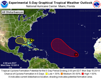
With that in mind, this year the Commerce Department's National Oceanic and Atmospheric Administration's National Hurricane Center introduced an experimental five-day Graphical Tropical Weather Outlook to complement its text-only product for both the Atlantic and eastern North Pacific basins. This new outlook provided easy to understand graphics depicting the likelihood of development and the potential formation areas of new tropical cyclones over a five day period. The hurricane center also introduced an experimental Potential Storm Surge Flooding Map for those areas along the Gulf and Atlantic coasts of the United States at risk of storm surge from an approaching tropical cyclone. First used on July 1 as a strengthening Tropical Storm Arthur targeted the North Carolina coastline, the map highlighted those geographical areas where inundation from storm surge could occur and the height above ground that the water could reach. This information was vital for emergency management authorities and the public in the affected areas. 

Additionally, upgrades to NOAA’s newest hurricane model, the Hurricane Weather Research and Forecasting (HWRF), produced excellent forecasts for Hurricane Arthur’s landfall in the Outer Banks of North Carolina, and provided outstanding track forecasts in the Atlantic basin through the season. The model, developed by NOAA researchers, is also providing guidance on tropical cyclones around the world and is used by several international operational forecast agencies. All of these improvements are an integral part of the ongoing evolution currently underway at NOAA's National Weather Service.

Organizations and Groups

  • National Oceanic and Atmospheric Administration
  • National Weather Service

Related content

Jul172014

200-b1.jpg

A view of the Pacific coastline along Santa Monica, California
Image(s) included
Post a comment

Guidance Aims to Improve Community Resilience to Coastal Hazards

EnvironmentNational Climate AssessmentNational Coastal Zone Management ProgramEconomic Recovery and Resiliency
Do you live on or near the coast? According to the latest population data, more than 39 percent of Americans lived in coastal shoreline counties and the number is growing...

Oct292014

154978495.jpg.crop_.article568-large.jpg

Satellite view of Superstorm Sandy, 10-29-12
Image(s) included
Post a comment

Two Years after Sandy Landfall, Commerce Continues to Help Affected Communities

EnvironmentHurricane SandyEconomic Recovery and Resiliency
In the two years since Hurricane Sandy made landfall on October 29, 2012, the Department of Commerce, through its National Oceanic and Atmospheric Administration (NOAA),...

Jul302014

drtoolkit_revised5_9-03-233x300.jpg

EDA and the International Economic Development Council Create User-Friendly Tool to Help Communities Recover Their Economy after Disasters
Image(s) included
Post a comment

EDA and the International Economic Development Council Create User-Friendly Tool to Help Communities Recover Their Economy after Disasters

EnvironmentDataEconomic Recovery and Resiliency
Everyone sees the destruction caused by a natural disaster – the loss of life and property make headlines for weeks. But natural disasters can have lasting effects that don’t...
/*Fix video embed transcript line height which was set to 0, squishing transcript to one line.*/ .file.view-mode-embedded_video { line-height: inherit; }

Source URL: https://2014-2017.commerce.gov/news/blog/2014/12/noaas-national-hurricane-center-implements-new-products-help-us-coastal

Links:
[1] https://2014-2017.commerce.gov/news/blog/2014/12/noaas-national-hurricane-center-implements-new-products-help-us-coastal
[2] https://2014-2017.commerce.gov/node/904#comment-form-collapsed
[3] https://2014-2017.commerce.gov/categories/environment
[4] https://2014-2017.commerce.gov/categories/operational-excellence
[5] https://2014-2017.commerce.gov/tags/economic-recovery-and-resiliency
[6] https://2014-2017.commerce.gov/media/photo/gwtoexample0png
[7] http://www.noaanews.noaa.gov/stories2014/20141124_hurricaneseasonwrapup_2014.html
[8] http://www.nhc.noaa.gov/news/20140630_pa_FiveDayOutlookGraphic.pdf
[9] http://www.emc.ncep.noaa.gov/HWRF/index.html
[10] http://www.weather.gov/