Jun012016
Posted at 11:58 AM
Post by John Thompson
The following is a cross-post from the U.S. Census Bureau's Director's Blog
Today marks the beginning of the Atlantic hurricane season. These storms are among nature’s most powerful and destructive phenomena, and they have the potential to affect a large portion of U.S. residents. The 185 coastline counties along the Atlantic and Gulf of Mexico – areas that are most threatened by Atlantic hurricanes – have a combined population of 59.2 million.
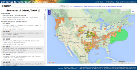
Emergency management officials can access statistics about communities in storms’ paths through the U.S. Census Bureau’s OnTheMap for Emergency Management tool. It’s a web-based resource that provides a live view of selected emergencies and weather events in the U.S., 24 hours a day, 7 days a week. It automatically incorporates real-time updates from federal sources so you can view the potential effects of hurricanes (and other disasters) on America’s population and workforce. The Census Bureau and the National Oceanic and Atmospheric Administration – both within the Department of Commerce – have worked together to bring you this real-time data.
OnTheMap for Emergency Management uses rich, local socioeconomic and demographic statistics from the American Community Survey and other Census Bureau data sources to give a detailed look at affected areas. It gives you information on the number of people potentially affected by a storm, as well as some of their characteristics down to the neighborhood level – for example, what percentage of residents are 65 or older, or what local employment patterns look like. The Census Bureau provides vital economic and demographic data to federal and local emergency management agencies, which can use this information to better assess hurricanes’ impact on coastal populations. For example, following Super Storm Sandy, New Jersey officials used our data to estimate the volume of traffic in affected areas.
The Atlantic hurricane season lasts from June 1 through November 30. If you live in a hurricane-prone area, you can find safety and preparedness tips atwww.ready.gov/hurricanes. You can also visit the National Hurricane Center for the latest tropical storm forecasts and follow the National Weather Service for active weather alerts.


