Dec232016
Posted at 1:27 PM
Guest blog post by Robert Sienkiewicz, Assistant Center Chief for the Longitudinal Employer-Household Dynamics, U.S. Census Bureau
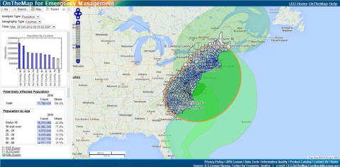
As we are poised for winter, we are fortunate to have a tool that enables deeper understanding of the potential effects of climate events such as severe weather. The U.S. Census Bureau’s “OnTheMap for Emergency Management” is a public data tool that provides an intuitive, web-based interface for accessing U.S. population and workforce statistics, in real time, for areas being affected by natural disasters. The tool allows users to retrieve reports containing detailed workforce, population, and housing characteristics. It was developed by the Longitudinal Employer-Household Dynamics (LEHD) program of the Census Bureau’s Center for Economic Studies (CES) and is available at <onthemap.ces.census.gov/em.html>.
The most recent version of OnTheMap for Emergency Management (Version 4.3) was released in June, 2016. The application provides real-time data about the people living and working in areas being affected by hurricanes, floods, wildfires, and winter storms. Data summarized by the application include American Community Survey (ACS) 2010-2014 5-year estimates and updating the LEHD Origin-Destination Employment Statistics (LODES) for 2014.
Americans live and work in areas affected by a variety of natural disasters, and the economic impact of such events is important to understand. To better enable planning, response, and recovery activities, emergency managers and others who work on the complex issues associated with these rapidly changing events need timely access to detailed information about potentially affected populations and workforces. Such information ranges from the number and location of people living and working within affected areas to the demographic characteristics of at-risk groups and the sectors of the economy that are particularly vulnerable to these events. Historically, answering such questions has been a challenge due to the disparate nature and technical incompatibility of social and economic data on the one hand and weather and natural hazard data on the other.
By bringing together statistical data and event/disaster data in an online, automated system, OnTheMap for Emergency Management increases the accessibility of these composite and real-time tabulations. Additionally, having these statistics in an easy-to-use interface with understandable visualizations highlights the availability of all these resources (statistical and economic data, weather events, and disaster declarations) freely provided by Federal agencies. While this application was initially designed to allow emergency managers and disaster recovery specialists quick access to relevant statistics, it also provides a window for the general public to see the how ongoing work of multiple agencies can be brought to bear when disaster strikes. According to the Census Bureau’s Rob Sienkiewicz, “OnTheMap for Emergency Management provides users with the ability to say ‘Here is what happened. We know that storm X hit and here is the potential impact on this community.’ OnTheMap for Emergency Management represents a combination of environmental science, economics, and disaster response.”
OnTheMap for Emergency Management will continue to undergo enhancements in the coming years. As possible, additional data sources (both statistics and events) will be integrated into the application. Work will continue to improve the application’s functionality, ease of use, and performance for users while maintaining its simple and efficient framework. Other next steps for the program are additional training with state partners, such as the labor market information staff in state of New Hampshire. Program staff are also providing webinars for the general public and working closely with Council for Community and Economic Research (C2ER).
OnTheMap for Emergency Management would not be possible without close collaboration between the U.S. Census Bureau and the National Oceanic and Atmospheric Administration's National Weather Service.
To access the tool, please go to: http://onthemap.ces.census.gov/em.html. For help and documentation, please go to: http://lehd.ces.census.gov/applications/help/onthemap_em.html#!what_is_onthemap_em. For comments or questions, please contact CES.OnTheMap.Feedback@census
This blog is a part of a monthly series highlighting the contributions of the Commerce Department’s agencies to the Open for Business Agenda. This month’s focus is Environment.


